Eagle River Community Water Plan
What is the Community Water Plan?
The Eagle River Community Water Plan (CWP) considers past, present, and future human needs and river health issues to identify opportunities to correct historical degradation and prevent and mitigate against non-desirable future conditions for environmental and recreational water uses.
The plan seeks to understand the independent and interactive impacts of population growth, water use, reservoir development, and climate change (air temperature and precipitation patterns) on human and ecosystem water needs.
It is intended as a guide rail to help current and future leaders make conservative, low-regrets decisions that provide water security to our communities while sustaining the productive, healthy, and beautiful river systems that have provided for our needs from past to present.
Reach-scale Assessment
Experts in multiple scientific domains including hydrology, geomorphology, botany, aquatic biology evaluated a set of ten state variables related to river health. State variable assessments evaluated current conditions and characterized the degree of departure from an expected reference state using a weight-of-evidence approach.
A variety of assessment methodologies—some rapid and coarse, some focused and intensive—produced evidence that reflects ecosystem processes across a range of spatial scales with using both quantitative and qualitatively approaches.
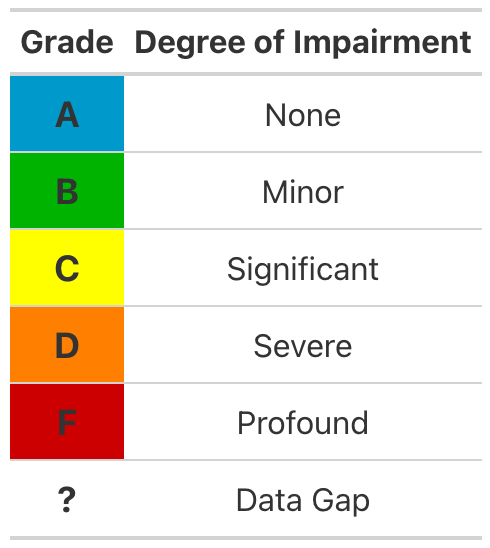
All assessment results were summarized in reach-scale Report Cards. Each Report Card summarizes the functional condition of river health variables using a familiar academic grading scale. This approach intends to quickly communicate technical assessment results to a variety of audiences.
Select a river reach in the map to view it’s Report Card
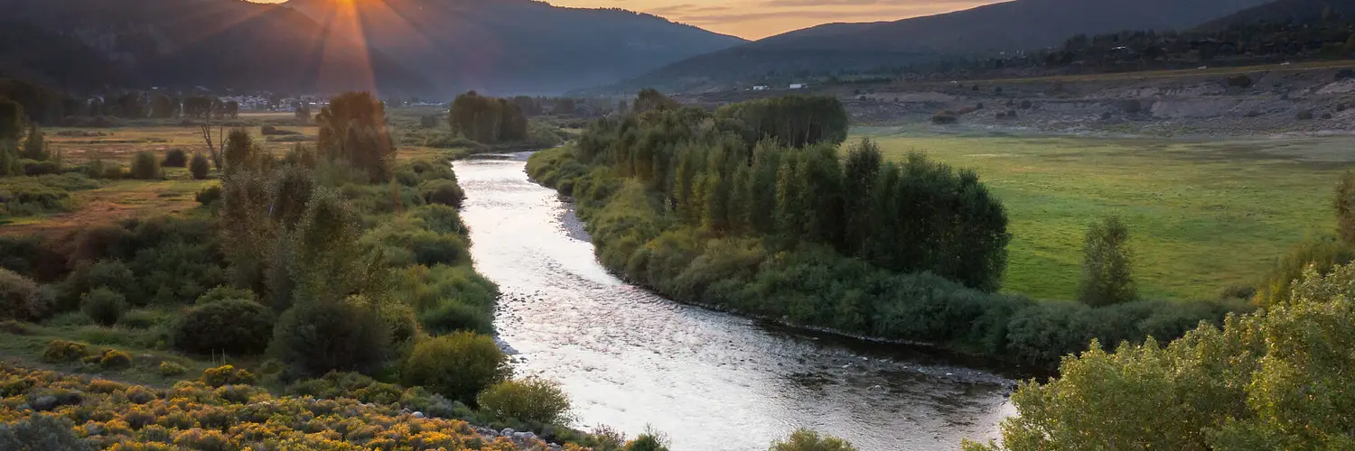
The CWP focused on priority mainstem reaches of the Eagle River from above Minturn to the Colorado Confluence, Gore Creek from East Vail to the Eagle River, and lower Brush and Gypsum Creeks below public lands.
Assessment Variables
Assessment variables consider individual aspects of river health. Report Card grades reflect the degree of departure or degradation of these variables from a highly-functioning reference condition.
Streamflow in rivers is often described as the master variable.
A river’s flow regime is the timing, magnitude, duration, and frequency of different flows. In the Eagle River watershed, a snowmelt-controlled regime means that during winter, low flows known as base flows dominate while snowpack slowly builds from October to April. From spring to early summer, the snowpack melts off. Rapid snowmelt feeds high peak flows, with a typical cresting flood flow observed in early June. As summer progresses, peak flows gradually recess back to base flows from July to September.
Flow regimes control channel form, water quality, and habitat quality both in the channel and on adjacent riparian and floodplain areas. Flow regimes also control biological cues for spawning, feeding, migration, and dormancy in aquatic species like fish and bugs, as well as reproduction and growth in many riparian plant species like cottonwoods and willows.
Flows are assessed using data from the top tier USGS stream gauge network data available in the watershed. Comparison to a pre-modern development flow condition to understand hydrologic departure from historical ‘reference’ conditions relied on the use of advanced hydrologic modelling tools developed by the Colorado Water Conservation Board and local government entities.
Existing conditions for streamflows are graded using several flow metrics strongly tied to river health and function including annual peak flow magnitudes, annual base flow magnitudes, total annual flow volume, and the annual return frequency rate for the highest peak flows.
Rivers don’t just transport water, they also move stuff. That stuff is sediment and organic matter. A river’s sediment regime includes the volumes and rates of sediment input from local and watershed-scale erosion, as well as the downstream transport and temporary or long-term system storage in channel features and floodplains. Sediment regimes have direct ties to channel form and stability as well as the type and quality of habitat for fish and bugs.
Sediment continuity and transport is assessed here by consideration of the Eagle’s ability to naturally produce and move its average sediment load downstream over time, and the annual return frequency of flushing flows, which scour out fine sediments and keep gravel beds clean and capable of supporting healthy bug communities and successful fish spawning.
Water quality describes the physical and chemical conditions in the river.
Pollutant loads from human activities both past and present can include dissolved metals, elevated nutrients, excessive fine sediments, and heat loading or diminished dissolved oxygen levels.
Existing conditions for the Eagle River are assessed using high quality datasets from USGS, CPW River Watch, CDPHE, EPA, ERC, and other local partner. Recent data for metals, nutrients, and water temperature are compared against existing statewide water quality criteria where available, and against EPA or scientific literature-backed criteria in other cases.
Healthy and intact riparian vegetation communities and floodplains buffer water quality, give rivers room to move, support diverse wildlife communities, and critically; provide long term protection of human infrastructure.
Riparian vegetation and floodplain physical conditions are graded based on the presence and linear continuity of undisturbed native riparian vegetation, the extent to which native vegetation still laterally covers floodplain areas, the extent to which floodplain areas have been physically altered or fragmented by roads, development, and agricultural uses.
Source data included aerial imagery, outputs from flood inundation models (i.e. FEMA flood maps and other GIS layers), digital relative elevation models, and local site visits/knowledge.
Channel structure and dynamics describes the extent to which stream channel dyamics (erosion, deposition, lateral movement) are natural and appropriate for the landscape context. Floodplain filling, bank armoring, riparian forest alteration and removal, dams, and in-channel engineering all alter channel dynamics. Existing conditions are assessed by expert knowledge of staff trained in geomorphology concepts, interpretation of aerial photo and GIS remote sensing datasets, and previous or recen site visits.
Aquatic habitat quality describes characteristics of macro-scale and micro-scale stream habitats available to aquatic life like fish and bugs. This includes the diversity of these habitats on a reach scale, and the appropriateness of a given habitat type in the greater watershed landscape context. Habitat structure includes features like pools, riffles, and backwaters, as well as the presence or absence of large wood debris, undercut banks, and water of different depths and velocities. Diverse, high quality habitat is required to support healthy fish and bug populations across a variety of life stages from juvenile to adult.
Habitat structure is assessed by expert site knowledge and input from aquatic biologists or other professionals with training in ecology and river science. Minimum streamflow thresholds ensure that movement is possible and refugia habitats exist throughout the river corridor, even in times of drought and temperature stress. Hydrologic connectivity is assessed as the degree to which in-channel structures like irrigation diversions or seasonal flow interruptions such as unmet instream flows impair the ability of aquatic life to move throughout the stream network for migration, feeding, refuge seeking, and spawning.
Aquatic insects form the base of the stream food web for other highly valued species like trout. The total number and relative abundance of different species also provides an important water quality indicator and a key ‘early warning’ system for degradation of water quality and instream habitat. Presence or absence of different fish species and their functional habitat and feeding guilds provides another indicator of overall stream health and vigor.
Aquatic macroinvertebrates are assessed against state instream aquatic life standard criteria for the region. Fish are assessed using aquatic survey data and expert inputs from CPW staff and other fisheries biology professionals; with a focus on whether or not the observed fish community on a reach is appropriate for a well-functioning river in a given landscape and channel type context.
Future Drivers of Change
The CWP evaluated potential future trajectories for Eagle River streamflows using advanced hydrological modeling tools, inference from observed current conditions, and numerous statistical trends analyses. Changes to streamflow have important implications on water availability, water quality, water temperature, and aquatic habitat quality.
![]()
The use of hydrologic simulation modeling results allowed for comparison of potential future streamflow trajectories with current and historical conditions. This ‘peak into the future’ allows decisions makers to consider how streamflow changes may affect various components of river health and the ability of local streams and rivers to support a variety of human uses. Multiple potential futures can be imagined for population growth and water use in Eagle County. The CWP evaluated impacts of population growth, development of new reservoirs in the upper watershed, and three different climate change trajectories were evaluated in ten different model scenarios.
Each report card includes a drivers of future conditions table providing an indication of the potential strength and directional change of variables over time under different influences.

According to the Colorado State Demographer, Eagle County’s population in 2020 was approximately 55,000 and is expected to exceed 70,000 by 2050. A growing population will increase local municipal demands and uses of water supplies. Increasing demand for water without major changes to existing use patterns and stronger efficiency/conservation measures may necessitate additional water diversions and/or new reservoir construction.

Significant possibility exists for development of new water storage and transmountain diversion (TMD) projects in the upper watershed due to increasing population growth and new water demand.
The Eagle River Memorandum of Understanding (MOU) outlined a conceptual agreement for further development of the Homestake Reservoir and diversion system that includes 20,000 acre-feet of average annual yield diverted east from the watershed for use by Colorado Springs and Aurora, and 10,000 acre-feet of firm dry year yield developed in one or more reservoirs for local West Slope uses.
New reservoir storage and TMD projects will significantly alter patterns of streamflow along the mainstem of the Eagle River, especially in upper reaches and tributaries. Alterations include reductions in peak flows, reductions in overall annual volumes, and the some potential for increases to late summer baseflows depending on how reservoir storage and summer augmentation releases are managed and allocated.
The Colorado State Climatologist reports that statewide annual average air temperatures increased by +2.3°F between 1980 and 2022. Statewide annual temperatures are projected to increase by +2.5°F to +5.5°F by 2050. Rising air temperatures will increase vegetative demands for water, dry out soils, and change patterns of snowmelt and runoff in Eagle County.
Anticipated hydrologic changes include earlier shifts in the seasonal onset of snowmelt, earlier runoff and peak flows, higher variability in peak flows, and significantly lower late season base flows. Even in wetter climate scenarios that consider increases to regional precipitation, streamflows will decline overall due to longer growing seasons, increased annual plant evapotranspiration demands, and drier average soil moisture conditions driven by warmer temperatures.

The Colorado Division of Fire Prevention and Control notes that the 20 largest wildfires in state history occurred since 2001. A warming climate and ongoing impacts from beetle infestations suggest that fire activity will only increase in the future. Stream segments below burned areas often experience significant degradation of water quality and aquatic habitat as streams are inundated by fine sediments and increased pollutant loads.
Mudslides and debris flows present a danger to life and property. Flashier streamflow responses to rainfall events in burned watersheds can produce floods that damage agricultural water diversions and municipal water treatment infrastructure.

Every town in Eagle County is positioned along the mainstem Eagle River, Gore Creek or the major western tribuataries of Brush and Gypsum Creeks. Historical and ongoing development of residential and commercial areas and transportation corridors in floodplains and other near-stream areas degrades riparian forests, decreases water quality, and, in some cases, directly impacts the structure of stream channels.
The addition of 15,000 people in the county by 2050 will necessitate additional development and water need. A growing population may also increase recreational uses of local streams and rivers. Increased recreational uses of stream and river corridors may degrade the quality of riparian areas.